Welcome to South Shore Hiking Trails!!

This site is for the explorer at heart!!
After years of hiking trails and backpacking, heading to places that sometimes took hours just to get to, the realization came, (partly due to this economy) that exploring your own backyard has many benefits. Those benefits can be very rewarding and lack the expense of those far away trips.
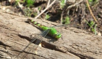
Never met one of these before hiking trails right here on the south shore!
We hope that this will be the residents' as well as the visitors' be all
guide to the hiking opportunities of the south shore as well as some
expanded recreational opportunities in the surrounding areas.
What
this website hopes to bring to you is what makes each trail covered
special, the history behind the area, and how it came to be a trail or
protected area.
Other features that will be covered and are important to hiking these trails are.....
the seasons and what they offer
tips and safeguards about the trails
Hiking
trails of any area offer a visitor the true "feel" of that land visited
and go off the beaten trail to those special places that usually only
the locals know about.
So, come explore this site, get your
hiking boots on, your water bottle filled and let's take a hike on one
of the south shore hiking trails.
Using this website
In the third column of each page that details a particular trail, an abbreviated trail quick facts section is located.
The information to the right under that same heading highlights what kind
of information is usually found there.
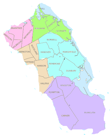
As you will notice on the map below the trails are divided into sectors.
These sectors were created to help organize the trail information and help the viewer to find what they need in an area quicker.
They are not official
Massachusetts boundaries.
The
south shore like many places in New England, is a place of undefined
borders. It can be defined in many ways but truthfully the south shore of Massachusetts is an area. There is no official
documentation of which towns are considered to be of the south shore.
Many
of the towns that do consider themselves of the south
shore, do so as the
town will actually border the ocean. Others do so as some of the
management agencies of the area include them in their plans of
management or development.
There are other towns that consider
themselves on the south shore as they lie inside or east of route 95
& the lower portion of route 495 and of course, all are south of
Boston.
The towns listed below are what
this website will be covering along with some additional selected
areas.
Quite possibly a later expansion to some of those "other" towns that consider themselves of the south shore.
The North West Sector contains the towns Randolph, Braintree, Weymouth, Holbrook shaded in pink.
The North East Sector contains the coastal towns of Hull, Hingham, Cohasset, Scituate shaded in lime green.
The Middle Eastern Sector contains the towns of Norwell, Hanover, Marshfield, Duxbury,Pembroke shaded in blue.
The Middle Western Sector contains the towns of Abington, Rockland, Whitman, Hanson, Halifax shaded in peach.
The Southern Sector contains the towns of Plympton, Kingston, Carver, Plymouth shaded in purple.
getting to the hiking trails on the south shore
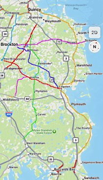
On the map below, route 3 is in a light gray and marked
This is the main expressway through the eastern part of the south shore.
If visiting the south shore from Boston, route 93 south connects to route 3.
Continuing on Route 93 South allows to you connect with routes 28 and 24.
These allow you to access the western side of the south shore and the Blue Hills Reservation,
Most of the towns of the south shore are accessed by route 3.
Most of the directions in the trail quick fact section use route 3 as a starting point for finding the trail head on the page you are viewing.
Other important routes on the south shore:
Route 3A in mustard to the right along the coast
Route 123 in fuchsia from Brockton to Scituate
Route 28 in Aqua next to Route 28
Route 18 in Red from Weymouth to Bridewater (and beyond)
Route 58 in lime green runs off Route 18 in Weymouth runs through most of the towns of the western sector ending in Wareham
Route 106 also in Red running from West Bridgewater to Kingston
Route 27 in royal blue running from Brockton to Kingston

Deer of Wompatuck
There is a comprehensive map of Ames Nowell on Maprika!
As well as several other south shore areas and more.
Get the app at App Store or Google Play. The map can be downloaded right to your smart phone.
 makes your skin crawl!
Tick season is still here.
Just like pollen every year they say it's bad! This season is no better.
Protect yourself!
Learn how you can protect yourself and how to remove a tick
Trail
Quick Facts
Note: All directions have a starting point from route 3 heading south.
On each trail page you will find this info here.
It will include:
- how to get to the trail
- what parking is available
- difficulty rating
- approximate trail length and time.
Distances listed are approximate.
Also included:
- water sources (for those who may bring a filter)
- other recreation
- maps
Local Events Website
because hiking trails are not enough to keep busy children occupied this summer!
If you are in or around the Hull area of the south shore another event finder is.




New! Comments
Have your say about what you just read! Leave me a comment in the box below.