hiking trails of whitman
whitman hanson trail


On my ever present quest to find hiking trails I came upon one in Whitman along the entrance to the Whitman Hanson High School.
Unnamed and starting along a utility line, I dubbed this the Whitman Hanson Trail for the reason that it starts at the high school bearing the same name and it starts (this end) in Whitman and ends in Hanson.
One thing about starting a hike at the high school is that there is plenty of parking.
The best parking for access to this trail are the spaces around the tennis courts and athletic fields to the school.
From here you walk a short way up the entrance road and cross the street where a dirt road leads off to the side of the high school entrance road.

The hiking trail quickly joins along a utility line. Across the line another trail leads into the forest but the land is posted here.
Continuing up the wide graveled service road that runs parallel to the high school entrance, at 1/3 mile views open up to that high school, with alternate entrances opening up from the upper parking lot.
Here the trail turns sharply to the right and crosses the utility line and enters the forest. No signs here!

The trail through the forest is pleasant, wide and flat.
Occasionally some rocks litter the way but mostly easy stepping.
The only other annoyance is that it is easily accessible to those who like to dump.
At the entrance into the forest someone has dumped many items and occasionally you will find old tires along the side of the trail.

At 1/2 mile,
that activity is stymied
as a fallen birch tree
blocks the way.
After this, the trail runs ever so slightly down hill and some roots appear.
There will also be evidence of water run off.

Fallen trees from past winters
make a natural entrance way.

As many trails on the south shore do,
this hiking trail passes through a stone wall.
Soon rockiness increases on the trail and it leads down to a wet area where some nice use of those dumped tires is made to cross a stream.
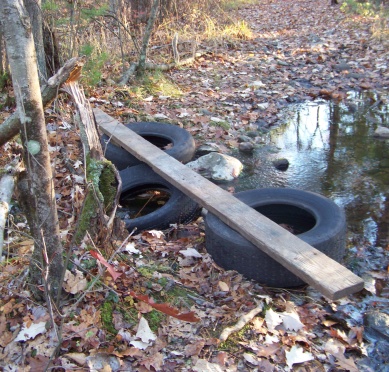
Not very pretty, but these
tires do serve a purpose!
The hiking trail then climbs a bit away from the stream.
At 6/10ths mile there is a trail junction. This seems to be a boundary as one of three hiking trails is headed by another no trespassing sign.
The other trail leads out to a second utility line.
The Whitman Hanson trail takes a hairpin turn to the left.

Generally happy to see no hunting signs
when hiking in the fall!
After the turn, the hiking trail then passes an area that seasonally looks to be wet and water runs off and flows across the trail. Today (late November) the run off area is wet but no flowing water.
A branch sticking into the fallen away
portion of a culvert was the only thing
that alerted me to it's existence.
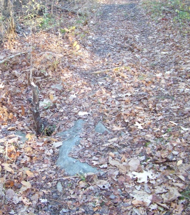
Shortly after that the trail passes over a flowing stream that has what looks to be a handmade culvert of stone. This appeared to me to be older, thinking this may have been constructed long ago lead me go on to do a bit of research.
What I found is that what I had always thought to be old stone bridges are actually culverts. The building of culverts dates back in this country right down to colonial times. They are built to support a road in times of high waters.
I did find an article that stressed that culverts made of pipe or any design that only took into account the travel over the water way, are destructive to the environment and cause problems for humans as well.
While the modern pipe culvert is fine for collected water management, a culvert over water supporting wildlife has to be treated differently.
For a culvert to work well with it's environment one needs to think about debris that can stop the flow of the water, causing problems.
Then there must also be thought to how large the culvert needs to be, fish and other aquatic life that could be interrupted by anything that causes the stream, brook or rivers natural flow to be interrupted.
Then there are the animals that travel waterways. Really the original stone design that the pipes replaced (most likely due to cost issues) were the best for continuing to support wildlife and aquatic life.
What is best, is allowing the riverbed itself to form the bottom of the culvert.
An arched shape or any other shape that allows whatever wild life that use that waterway to pass, and allows usual debris that flow down that water way to pass as well.

A very low arching culvert
for a small stream
Here in Whitman on this trail it is only a small stream but someone put that thought into the process.
Or just wanted to build a really cool old style culvert!
If not observant you will miss this small wonder in the woods!
There is lots to learn in the outdoors, sometimes in the most unassuming places!
for more specifics about stone culvert history
document showing environment problematic culvert designs

Once past this, the trail then travels through a stand of baby pine trees making the forest look thick.
There will be a narrower trail leading to the left in this area.
This leads to private property. Some of the land along the right of this trail to private property is fenced in.

On the main trail if you look
beyond the baby pines a bit
of a marsh can be seen.
The trail will now lead out to the other utility line. If following out you will find yourself on Birch Bark Dr. in Hanson.

Across the utility line the trail continues. It runs behind homes on Birch Bark Dr. on a much more narrow track.
Found signs of trail maintenance. This portion runs out to Acorn Dr. where a private property sign is posted at the beginning of that end of the trail.
Inside the forest or the beginning of the trail on this side of the utility line there are no posted signs to be found.
Not sure if this portion is totally on private land or partially (if at all). Whitman does not seem to have an inventory of conservation lands readily available.
- South Shore Hiking Trails ›
- Whitman ›
- Whitman Hanson Trail
Recent Articles
-
Eaton Pond Conservation
May 11, 23 12:38 PM
 The Eaton Pond Conservation sitting on the Braintree/ Quincy line is a wonderful hiking area with a varied mix of history and assorted landscape.
 -
Bradford Torrey Sanctuary update
May 09, 23 10:34 PM
Visit the completely updated version of the trail and sanctuary description and it's highlights. The town of Weymouth did a spectacular job of cleaning this gem up with several trailheads established… -
Ellis Estate Trails
Jun 08, 21 11:07 PM
 The Ellis Estate Trails in North Scituate are a collections of trails winding in and around the property they are named after.
Trail
Quick Facts
Directions:
From route 3 exit 38 head south on route 18. At intersection of route 27 (approx. 5 miles) take left. Follow route 27 through Whitman Center following the route to the right it takes onto Franklin St.
Approx. one mile Whitman Hanson High School will be on the left. Take the first entrance and park near the tennis courts.
Parking:
Plenty of parking for many vehicles.
Trail Time:
Light
Just under 3/4 mile to 2nd utility line.
Difficulty:
Easy
Water sources:
small stream on trail
Other activities:
wide enough for multi-purpose use.
x-country ski, snow shoeing, biking
New! Comments
Have your say about what you just read! Leave me a comment in the box below.