hiking trails of hingham
Triphammer Pond Conservation Area

There are many hiking trails in Hingham. If you are pressed for time or the weather is a bit chilly such as the day I explored this area, Triphammer Pond is a quick but interesting hike.
Getting to the trail from Leavitt St. is the first challenge. The Triphammer Conservation Area from this street is accessed by Popes Lane, a right shortly down the street. You will find small signs that point the way that are marked Triphammer Pond.
Popes Lane splits to the left on an older
narrower road with a newer development
going to the right. Along the way you
will find a "country road" going to the right
but this is actually a private way.
You will find the road leading to the parking lot at Triphammer Pond on the right just before the dead end sign.

The area is well marked by this sign.
The approximately 1/4 mile drive down this dirt road to the parking area will be rough going in some spots.
Once to the area, the parking lot can hold several vehicles comfortably.
There will be two hiking trails to choose from to start your journey.

I chose the one on the left that looks like a boat launch.

Though in late summer with drought
and lily pads it doesn't look so much
like a good launch site!

Hidden and to the left you will find a narrow trail that will circle the pond.

Once on this hiking trail, almost immediately another small narrow trail to the left emerges that brings you to a rocky area to look out over the pond.
The trail on this side runs close to the edge of the pond and is a typical south shore hiking trail being that it is rocky, root filled, and pine needle laden.
Soon down the trail you will find another small trail to the right. This time it leads out to a rocky outcropping above the pond.
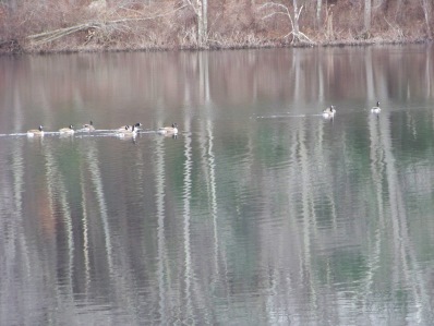
Just as I wandered out to this point, a flock of Canada Geese touched down on the pond. I formerly called these Canadian Geese but that term, after a bit of research, I have learned is incorrect.
Just at 1/10th mile, I found a pile of boulders and the trail started to climb uphill.
At 1/5th mile, I found yet another path to the right leading to a boulder with a good view of the island in the pond.
At
just about 1/3 mile, I came upon a picnic table. It was a bit of a strange sight in that it appeared almost tossed here. It looked to be very new and well made, but
the area was not cleared enough for the table (maybe a spring project?)
Soon after the trail went downhill a bit and the distant noises of traffic faded and the forest became silent.
On
this early winter day I found the edges of the pond have started icing
over. Skating here if it is allowed would be very pleasant. The island
would make a great resting place.
At 4/10 mile, the trail leads away
from the shore a bit into the forest. This time of the year though, one can
still see the pond through the leafless trees.
At 1/2 mile, views of
the opposite side of the island open up. Then the trail opens up to
another viewing area and here you will notice a "leg" of the pond that
is not easily viewed from the parking area.
Following the trail once again near the shore, for a short distance the rocks and roots disappear leaving only the pine needles.
The trail leads downhill and the roots start to appear again. The first of several fallen trees most likely from the storms of last winter appear. Too low to the ground to go under and being a short person a bit of a struggle to get over.
The trail now skirts a marsh area of the pond. The hiking trail passes thru an old stone wall with some sort of cement marker on the other side. This may actually be the boundary of the conservation area. After this stone wall a brook feeds into this marsh area and the trail runs along this brook and climbs up to a road in Wompatuck State Park.
Once on this road, taking a right will lead you over and past the marsh area as well as a well flowing stream that feeds the pond. After this stream you will find a trail going to the right. Immediately after, another narrow trail going to the right leading down a steep hill.
At 4/5th mile, you will re enter the Triphammer Pond Conservation Area. There is fencing that distinguishes the two properties but no signage.
You will now find yourself on the opposite side of the "leg" portion of the pond.
At just about one mile another down tree, this time with a trail around it.

Shortly after this tree you will find some re purposed tree trail work. Walkways over wet areas using material from the forest.

The trail splits at this area. Following to the left, the trail winds uphill to another access area of the conservation land.
Following that trail, signs of heavy use by the deer population were found.
Back at the split, the Triphammer Pond hiking trail continues straight along the shore of the pond again and a little less than 1/4 mile later comes to the area where a mill once stood.

The remains of the building still exist.
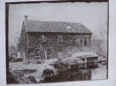
The original mill was a saw mill built in 1700. The name of the pond at
that time was Saw Mill Pond. In those early American days lumber
production was a primary business.
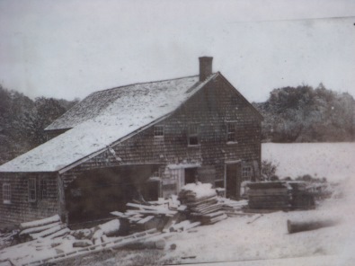
In 1823 the original mill burned down and a new one was erected. This one contained a triphammer, no doubt using the water from the pond to power it.
A triphammer is a
heavy hammer used to strike something repeatedly and is powered by a cam
that lifts the hammer and lets gravity do the work of bringing it back
down again.
The name of the pond then was changed to Triphammer and another smaller pond in the area took the name of Saw Mill pond.
The trail continues a bit over a lane that is fenced along the pond side and over a short bridge.

Once over, I found my Canada Geese friends again. There was one that was
"talking" or should I say directing the flock? The one on the far right is
the one leading. They seems to the perched on a partially submerged island.
Once this one called out to the others, they all seemed to migrate over
to this island.

summer at triphammer pond

The trails become lush with
vegetation in the summer months!

The pond mirrors a beautiful summer day!

once over this bridge

You will find part of what the area has to offer!
- South Shore Hiking Trails ›
- Hingham ›
- Triphammer Pond
Recent Articles
-
Eaton Pond Conservation
May 11, 23 12:38 PM
 The Eaton Pond Conservation sitting on the Braintree/ Quincy line is a wonderful hiking area with a varied mix of history and assorted landscape.
 -
Bradford Torrey Sanctuary update
May 09, 23 10:34 PM
Visit the completely updated version of the trail and sanctuary description and it's highlights. The town of Weymouth did a spectacular job of cleaning this gem up with several trailheads established… -
Ellis Estate Trails
Jun 08, 21 11:07 PM
 The Ellis Estate Trails in North Scituate are a collections of trails winding in and around the property they are named after.
Trail
Quick Facts
Directions:
From route 3 take exit 32 on Derby St toward Hingham. At the second set of lights just past the shopping plaza take a left onto Cushing St. Follow to end and go left on route 228 following till Leavitt St right and right again on Popes Lane. Right on access road to Triphammer Pond Conservation Area.
Parking:
At end of access road with room for several vehicles.
Other access and parking in Wompatuck State Park. Take route 228 to Free St. Follow road at left of gate house at entrance to the park. Note: the gate house has been removed. This road is the first left after the main entrance sign.
As an alternate you can park at the first lot on the left and walk down the road to the trail.
Triphammer Pond will be on the left. Parking on the side of this road
Trail time:
1/2- 1 hour
Difficulty:
easy- moderate
some hills, rockiness, and climbing over fallen trees
Water sources:
the pond itself and the stream feeding in and out of the pond
other activities:
non motorized boating, skating,
New! Comments
Have your say about what you just read! Leave me a comment in the box below.