hiking trails of halifax
Stump Brook Sanctuary


The Stump Brook Sanctuary is a beautiful 263 acre slice of semi wilderness.
Owned by the Audubon Society, it isn't listed with the host of its usual properties.
It is only listed on an additional sanctuary page and though managed it seems to be
mostly left untouched.
Though area residents do step in!
This untouched feel to the sanctuary may be to the advantage of those
who like to explore quiet corners of suburban wilderness.
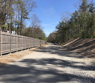
There is no formal street access or parking area dedicated to the Stump Brook Sanctuary.
The newer Halifax entrance to Burrage Wildlife Management Area is the closest
parking available.
This allows those who want to explore the Sanctuary to enter quickly as it abuts this other well used Conservation Area.
The Halifax entrance is on Elm St about a mile south of the Hanson entrance.
This entrance brings you into the most southern portion of Burrage along a lower
abandoned cranberry bog.
Coverage for hiking and history on Burrage Wildlife Management is on the Hanson page.

Once parked and out to the cranberry bog take a right.
Follow this down to where it starts to curve and follow the bog.
At this curve but straight ahead are some large boulders
making it appear that the forested cart path beyond is closed.
This is simply the boundary between the two properties.
 Boulders and a narrow trail beyond with several fallen trees give the appearance of a closed area.
Follow past the boulders and into Stump Brook Sanctuary. No signs anywhere to inform!
At this point you have traveled approximately ¼ mile.
Here will be a loop trail description of the sanctuary, but there are many more trails to explore.

The trail starts somewhat narrow with several downed trees crossing the path.
Soon most of those disappear and the trail widens and becomes more defined.

Shortly you will pass over the first of several culverts.
This first one crosses Stump Brook.
Just after crossing the culvert the trail splits.
Depending on which end of the loop you would like to start with this trail split just brings you closer to that trail start.
The trail description goes to the right. Along this trail the Stump Brook is on the right and a vernal pond is on the left.
The trail not taken to the left is easily seen in early spring when the trees are without leaves.

At .35 the main loop trail intersects and going right the hiking trail soon curves to the left.
The Stump Brook Sanctuary trail circles a large wetland looking pond.
Many call this the Stump Brook Pond. One can clearly see the brook run through this pond.
The trail widens out and runs mostly flat.
At .42 the left clears enough to get good views of the pond.

At .50 there is a large pine blocking
the trail. It has been there for some
time as the trail goes to the left
around this obstacle.
Shortly after, the hiking trail passes
over another culvert that allows the
water from the pond portion to
flow into the brook.

A few short steps later the trail curves to the left again hugging the wetland pond.
To the right a rustic bridge crosses an unnamed tributary to Stump Brook.
The trail on the other side of the brook is interesting and worth an explore, but it eventually leads into private property.
Continuing on the Stump Brook Sanctuary trail which remains wide and pleasant with some dips here and there.
It continues to follow the pond on the left and the tributary on the right.
Further down and looking across the tributary it appears that there may be a narrow path on the other side but if so again most likely made by area residents.

Here and there along this stretch
there are sandy spots.
Ideal conditions for those who like
to bicycle along wooded trails.
This stretch of the loop through
the Stump Brook Sanctuary runs for
¼ of a mile and then comes to
another intersection at .80 miles.

To the right is another rustic bridge but this one has a bit of railing.
Beyond this bridge there are many trails for further exploration. The loop goes left here and a few short steps comes to another junction.
Continue left to stay on the loop trail.
Another trail runs straight into the same direction as the other trails beyond the bridge but this one stays to the side of the tributary.
On a subsequent hike I found this to run further into Halifax toward Lingan St.
 A look to the east on Stump Brook. Google maps show it flows out of the West Twin lake of Monponsett.
Staying left for the loop trail the way continues wide and runs through an area that is wetland on both sides. The pond isn't seen here.
This part of the loop you will find the Atlantic White Cedar trees that are a highlight of this conservation area.
At .95 you will find a blaze on a tree marking the boundary of the Division of Fisheries and Wildlife management area.
Shortly after this blaze the hiking trail passes over yet another culvert.
Here the pond is once again seen and continues to the right as well.

At 1.12 the trail comes to another intersection. The Stump Brook Sanctuary loop trail goes left and the cart path we are traveling continues straight.
The trail straight runs through an area heavy with the cedar trees and wetland.
The forest is thick and dark on both sides. It runs almost ½ mile and comes to another junction where it turns right.
It is most certainly back in one of the main areas of Burrage Wildlife Management Area but I did not continue.
To the left of this trail at the intersection was a canal like most cranberry bogs have alongside it now with vegetation growing around it.
On the other side of the canal the usual sandy roads found in Burrage Wildlife Area could be seen.

Back at the loop I took the left. Here the trail continues much the same, cart path sized level but with
the Cedar wetland to the right and the wetland pond to the left.
Along this stretch the wetlands of the pond gave way to semi protected waterway where often you will
find turtles sunbathing on clumps of grasses or mallards swimming through the bush and trees that grow along the side.

At 1.27 there is a tree partially fallen but not completely. Growing up but more sideways perfect for a climb out above the water for a clear view of the waterway.
Surely if someone did this and remained for a stretch of time there would be much wildlife to see!
Shortly after the tree at 1.40 we arrive back at the original intersection marked on this side by several large boulders.
Take a right to follow back into the main trail at Burrage Pond Wildlife Area being careful to stay to the right at a split not easily seen coming in.
It leads backwards when first entering the sanctuary. Many connecting trails lead from this trail if you care to explore!
Back at the parking lot the full hike comes in at 1.75. If you have explored any of the other trails or side diversions the hike will come in at 2.50 or considerably more if you get carried away.
Bring Snacks!!
- South Shore Hiking Trails ›
- Halifax ›
- Stump Brook Sanctuary
Recent Articles
-
Eaton Pond Conservation
May 11, 23 12:38 PM
 The Eaton Pond Conservation sitting on the Braintree/ Quincy line is a wonderful hiking area with a varied mix of history and assorted landscape.
 -
Bradford Torrey Sanctuary update
May 09, 23 10:34 PM
Visit the completely updated version of the trail and sanctuary description and it's highlights. The town of Weymouth did a spectacular job of cleaning this gem up with several trailheads established… -
Ellis Estate Trails
Jun 08, 21 11:07 PM
 The Ellis Estate Trails in North Scituate are a collections of trails winding in and around the property they are named after.
Trail
Quick Facts
Directions:
Being a bit away from route 3 this is a drive depending on where your start point is.
From route 3 Exit 27 in Pembroke follow route 139 west.
Follow through two sets of lights, then take Water St on the left.
Follow Water St to it's end and left on Route 53.
At the next set of lights take the right on Route 14.
Follow Route 14 through Pembroke Center. It will take a right onto Mattakeeset St.
Continue following till Route 14 takes a right on Maquan St at a small traffic circle.
Continue straight on Mattekeeset St to it's end in Bryantville and go right on Route 27,
Continue straight through the lights that intersect with Route 58.
Continue on Route 27 through Hanson Center past the MBTA. Approximately 1/4 mile Elm St will be on the left with Mo's Place restaurant on the corner.
Follow Elm St down past the Hanson Burrage Wildlife Management parking area and into Halifax.
Hudson St is just after the line. Continue till just after Pond St on the right. The parking for the Halifax Entrance is on the left just after #149
Parking:
Long drive with good sized parking area. Can accommodate many vehicles.
Trail Time:
Moderate to Lengthy
Loop is 1.75 miles with many added side trails making this a possible full day hike!
Difficulty:
Easy
Water sources:
Water everywhere! Stump Brook, a tributary and many small streams
Other activities:
Birdwatching, Bicycling, horseback riding, x-country ski, snow shoe
Dogs:
No bags but the area with its plenty of water sources and less traveled atmosphere is perfect for a dog that likes to romp and explore!
New! Comments
Have your say about what you just read! Leave me a comment in the box below.