hiking trails of hanson
Rocky Run Conservation Area


The Rocky Run Conservation Area with it's hiking trails
form a ring inside of it's own property,
but are part of a larger hiking route that links
two other towns and their hiking trails to form an even larger loop.
The property is located on the Hanover/ Hanson town line on State St. in Hanson.
The Indian Head River flows through the area creating the two town's natural boundary line.
There is a small parking area on the Hanover side with a small trail down to a peninsula within the river.
Formerly I had thought this peninsula
WAS the property. Disappointed, I did
not pay much attention to Rocky Run.
Though an exploration of this small
peninsula should be included as part
of your hike at this conservation area.
Information about Hanson conservation property isn't as available as it is in other towns.
I found Rocky Run by an exploration of Tucker Preserve in Pembroke, one of the other properties forming the three town hiking trail loop.
The Wildlands Trust has a kiosk with a map at this property location and the map includes the full loop.
There it shows an access trail leading along the river and connecting to what they simply refer to as Hanson Conservation Land. Knowing that this "conservation land" is Rocky Run, I was now excited!
Before the hike at Rocky Run,
take the path down to the peninsula
within the Indian Head River.

Some wonderful views of the river
flowing beneath the bridge
over the Indian Head River!

You will find a small network
of trails on this peninsula,
helpful to fully explore this
little piece of scenic property!

The trails lead to the side
of the river where a possible
boat launch could be made.
Or just a good viewing point!

The down river view at
the tip of the peninsula!
The mileage includes the explore of this peninsula.

At the small parking lot,
located at what is Cross St in
Hanover, and crossing the town
line, a short walk back into Hanson
on the opposite side of the Indian Head
River, a jersey barrier will be found partially in the forest and beyond is the trail leading into the Conservation.
No signs announcing the property will be found here. To
access this property it is suggested to cross the street and use the
side walk over the Robert Hammond Memorial Bridge. The street is very narrow over the bridge and not a safe way
to travel.

Some beautiful views of the Indian Head River can be viewed at this bridge that those riding in a vehicle most likely don't get the chance to admire.
Past the bridge and following to the end of the guardrail.....
Cross again to access the path in.
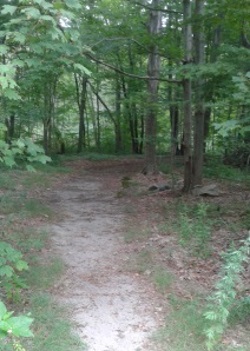
The trail in is wide here and starts with a slight downhill grade. The river on the left cannot be seen but is usually heard.

Shortly down the hiking trail it will start
to climb moderately and soon meet at
.24 with a black chain link fence.
Left side falls away as you climb the hill
up to the fence. Blocked views of the river
will appear at this point.
At .28 a small granite post is found on the trail.
Shortly after a trail junction.
The shorter loop trail leads straight and the intersecting trail that leads to the right will take you on a full tour of the property.
Caution here if going straight.
In the summer it is much easier to follow the trail.
There are many small trails that leave this main trail.
In the fall and most likely in the winter when trails are not as defined you can lose your way. Not a real problem here as the forest is pretty open. But there is much rocky and almost cliff like areas to be cautious about.

Going right and following along the fence, another path leading to the left will take you back to the trail that went straight.
At
.36 another intersection.
Going right is blocked by a fence. Go left on a continued cart path sized hiking trail. Found a faded golden blaze on a tree.
The forest is maintained on the left here and dense vegetation on the right.

At .44 another trail leads to the right not as cleared looking. This is an access trail for a neighborhood street. It runs about .20 and has two ending points.
One at the end of either a road or shared driveway. Then it continues and ends at a private property.
Along this hiking trail are faint trails to the stream the area is named after, Rocky Run.
Very rocky along the hill side down to the stream and potential for more trail development along here!
Found a ridge above the stream and a faint trail that would make a wonderful scenic loop.

After investigating this trail and
back out on the main cart path
at .89 taking a right, shortly after
on the left a trail leading down to
an open area that looks like many trees had been cut down.
In the middle a fire ring.
Continuing on the trail it leads downhill and through a very large downed tree that was cleared just enough to pass through.

At .95 the small path to the
right that leads over Rocky Run
by way of rocks.
Smaller trails lead to the left uphill,
our way is straight, but starts to
increasingly make a sweeping left turn.
The trail becomes narrow with the Indian Head river on the right and the hill side on the left.

The hiking trail leads through
vegetation and becomes rocky and rugged.
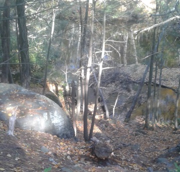
At one mile the trail leads through an area
that has been abused.
Here are rocky outcrops and cave
like openings in the rock.
Trails lead up to the top where the camp ring exists.

The trail leads away to the right continuing on a rugged path.
It passes an area that almost looks like a rock wall leading into the water. Start of a former damn?
All along this way there are several trails leading up hill.
At 1.13 miles of our journey this trail will lead uphill away from the river as well.
It
almost leads up like a switchback (zig zag pattern ) up the hill.
Comes into an area of many small trails. One leads down to an overlook area over the river but with limited views.
Soon the trail will lead out to the chain link fence started at.

View of Indian Head River
from lower rugged hiking trail.
There are a couple of areas to access the Indian Head River or alternately access Rocky Run from the river.

One of the areas where caution is needed!
- South Shore Hiking Trails ›
- Hanson ›
- Rocky Run Conservation
Recent Articles
-
Eaton Pond Conservation
May 11, 23 12:38 PM
 The Eaton Pond Conservation sitting on the Braintree/ Quincy line is a wonderful hiking area with a varied mix of history and assorted landscape.
 -
Bradford Torrey Sanctuary update
May 09, 23 10:34 PM
Visit the completely updated version of the trail and sanctuary description and it's highlights. The town of Weymouth did a spectacular job of cleaning this gem up with several trailheads established… -
Ellis Estate Trails
Jun 08, 21 11:07 PM
 The Ellis Estate Trails in North Scituate are a collections of trails winding in and around the property they are named after.
Trail
Quick Facts
Directions:
from route 3 exit 27 head west on route 139. This starts as Church St, turns into Schooset St. At the lights that intersect with route 53 turn right. At the next set of lights at Broadway St go left. Follow Broadway around the bend and continue approx. 1 1/2 miles til the next major intersection. Take a left on Cross St. The parking space is immediately on the left.
Parking:
3-4 vehicles at dirt parking area along Cross St.
Trail Time:
Light- Moderate
possible 2 miles of hiking full property including the peninsula and full tour of the property. Much longer hike can be done by crossing Rocky Run at stepping stones and using access path to Tucker Preserve.
Difficulty:
Mostly Easy:
Caution though, some steep trails and cliff like areas near clearing area
Water sources:
Indian Head River and Rocky Run stream
Other activities:
Bicycling on cart path and across Rocky Run on upper access paths leading to tucker preserve,
snow shoeing, x country skiing, kayaking
Dogs:
no dog bags here but,
 Dogs and their owners can get a good workout here
 Dogs often get a swim in the river!
New! Comments
Have your say about what you just read! Leave me a comment in the box below.