hiking trails of pembroke
Misty Meadows Conservation Area


Misty Meadows Conservation Area and it's hiking trails are a bit hidden, mostly due to it's entrance being obscured by storm damage.
 damaged granite sign at entrance to misty meadows conservation area
The granite sign that once announced the entrance to the conservation area lays face up.
The main trail is obscured as well, with the entrance hidden by
vegetation and access is by way of an easement along private property.
It
is a small plot of town owned property with several access points, one
being the North River, if you arrive by canoe or kayak!
Another good feature is that the
hiking trails here back up and
link to those of the Willow
Brook Farm Preserve.
A larger property owned
by the Wildlands Trust and
lie in Pembroke as well.

If entering at Ingham Way off Misty Meadow Lane in Pembroke, look for two rock pillars to the right of #34.
Park along the street. At these two pillars there looks to be a start to a driveway.
The
fallen granite sign marking the entrance seems to have been pushed over
in one of the hard winter storms of the last few years.

To the side of the private property,
along the fence you will find the
gate to the conservation property.
The path in runs along the neighbors
fence where wild strawberries and
raspberries grow.

At the entrance of the forest,
the trail runs through a rock wall
and then you will find a kiosk with
a map and info about the property.

Across from the kiosk and leading left
from the main trail is the trail leading
to Willow Brook and the
Kings Terrace Entrance.

The main trail continues
straight as a wide grassy path
with a mix of pine needles
and leaf carpet.
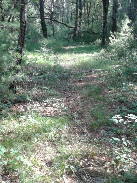
Though a short hike,
it is a mildly winding,
pleasant journey!
At just over 1/4 mile there is a marker claiming the North River Trail.
The trail leads through another rock wall, this one lower. The hiking trail becomes narrow and starts a downhill jog.
The trail goes through a bit of wet area and then at .42 comes to the side of the North River with a bench.
 The bench helps mark the Misty Meadows from the river side
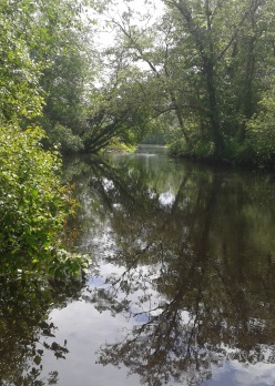
Some very nice views of
the Herring Brook, which lead
out to the North River at the
end of the North River Trail.
For a longer hike accessing Willow Brook, follow
the main trail back to the kiosk and go right at the marker across from
the kiosk.
Follow til the next marker that points right for
Willow Brook. The trail straight leads out to Kings Terrace though
becomes a bit faint.

Continuing on the access path to Willow Brook Farm, the path
starts as a narrow well laid out route but becomes less maintained
looking.
At .90 of the total journey the trail turns right. Then becomes well maintained once again.
At
.95 the trail runs through a rock wall. At 1.05 there are no markers
but a tree wrapped with orange and green ribbons. Here the access trail
to Willow Brook will take a right.
At 1.15 you will notice the trail running parallel to another rock wall.
At 1.28 the trail leads away from the rock wall on the left but another appears to the right of the hiking trail.
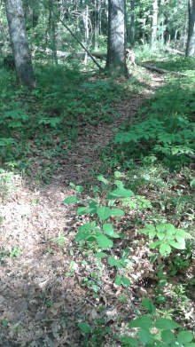
 nearing the end of the hiking trail connecting misty meadow to willow brook
At 1.32 you will come upon a Holly tree. Always a welcome sight in winter!
At 1.42 you will come across some large pines that have been cut into logs.
At 1.46 you will enter Willow Brook at an intersection.
Going right will bring you toward the main part of that property and a Wildlands Trust blaze on a tree lets you know you have arrived at your destination.
Going to the left will bring you through one of the many meadow portions of this property.
Always a nice hike in any weather and a good addition to this initial hike.
It will loop back to this same intersection but not before reaching a boardwalk and bridge section that you will arrive at quicker if taking the right when you first enter Willow Brook.
Some Hiking Trails mileage
Wandering the Misty Meadow main trail and back
to the Willow Brook Access Trail = .80 miles
Willow Brook Farm Access Trail = .66 miles
total 1.46
Misty Meadow Water Route
The way into Misty Meadows Conservation does have a feel like you are trespassing, so if you have a canoe, kayak or other means of water transportation, or just want a good rounded out work out, the water access route may be for you.

Best entry point is at Chapmans Landing
in Hanover or as some just call it the Hanover Launch.
Located on Indian Head Dr. off W.Elm St, the sign calls it a car top boat access, but other signage suggests that small motored boats can launch here as well, usually dependent on the tide.
There are two granite slabs at the end of the paved ramp. At high tide time these are completely submerged.
Once in,
you will be heading left,
the first part of the journey is shady
and resembles the water version of a rustic country lane.

After a few twists and turns
and heading past trees that have
fallen in the water, the river widens
out and a grassy meadow forms on the right.

The distance was surprisingly
longer than I thought. It always
looks so much shorter on a map to me!

Yet my interest was kept by all the vegetation and wildflowers that were in bloom along the way.
Another
factor was the multitude of bird and wildlife found. Many flew over marsh
meadowlands to the right. I saw at least two Herons, one found it's
lunch on the river!
I picked a day that seemed to be a constant switch between sun and clouds.

On my map (google) it shows what looks to be an island in the water but when the water is high it is just a large clump of the meadow in the river. It may be an island at low tide.
Soon after the "island" the water junction of the Indian Head River and Herring Brook appears. Heading to the left is the start of the North River. Our journey goes to the right on the Herring Brook.
For more info on paddling the North River, the wild turkey paddlers have a nice guide.

The Herring Brook starts wide,
but soon gets narrower and winding.
This portion of the paddle took longer
than expected, but was very pleasant.

The tall grasses that line the
North River continue on the brook
and soon line both sides of this
interesting little river.

Soon we arrive at our destination,
marked by the bench at the end
of the North River Trail!
- South Shore Hiking Trails ›
- Pembroke ›
- Misty Meadows
Recent Articles
-
Eaton Pond Conservation
May 11, 23 12:38 PM
 The Eaton Pond Conservation sitting on the Braintree/ Quincy line is a wonderful hiking area with a varied mix of history and assorted landscape.
 -
Bradford Torrey Sanctuary update
May 09, 23 10:34 PM
Visit the completely updated version of the trail and sanctuary description and it's highlights. The town of Weymouth did a spectacular job of cleaning this gem up with several trailheads established… -
Ellis Estate Trails
Jun 08, 21 11:07 PM
 The Ellis Estate Trails in North Scituate are a collections of trails winding in and around the property they are named after.
Trail
Quick Facts
Directions:
To Trail Head: route 3 south exit 27, follow route 139 west till it's intersection with route53. At the lights with route 53 go left. Take the 2nd right onto Misty Meadow Rd and a left on Ingham Way. Find # 34, the trail is on the right side of their property.
************************
This can also be accessed through Willow Brook Farm
enter misty meadow by way of the Todd Trail
*********************
To the boat launch:
Follow the same directions as above, but at the lights with route 53 take a right. At the next set of lights at Broadway st go left. Shortly down the street W.Elm will intersect to the left, take that. Take the 2nd left onto Indian Head Dr. At the end of the street will be the boat launch AND Iron Mine Brook Trail.
Parking:
Ingham Way:
a few cars curbside
Chapman Landing:
up to 20 vehicles
Trail Time:
Light to Moderate depending what you add on.
Difficulty:
Mostly Easy:
Water sources:
Herring Brook
Other activities:
Kayaking, birdwatching

New! Comments
Have your say about what you just read! Leave me a comment in the box below.