hiking trails of hanover
Melzar Hatch Reservation


The hiking trails at the Melzar Hatch Reservation are part of Hanover's open space properties, but are owned by the Wildland Trust.
Seemingly a collaboration between the town and the trust.
Nothing appears on the Wildlands Trust website about the property. The property contains 47 acres labeled as cross country ski trails used in all seasons for hiking.
There are several access points to the trails as it runs along the boundaries of both the Middle and the High School as well as the Cedar Elementary.
I chose the same area used to park for the Colby Phillips Trail along the entrance to the middle school.
There are additional spaces in the parking lot near the reserved ones along the route one needs to take to access the forested part of the hiking trails.
Parking at the side of the entrance to the middle school, you will follow the entrance up to the school. Then take a left just before the pavement of the parking lot and cut across the lawn along the side parking area.
Use the road that follows behind the school and follow that to the back of the building where the fields are.
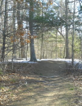
Go onto the field and follow the forest edge til you find either a narrow trail, this will lead to the wider trail, or continue on and find the start of the wider trail.
You will have already traveled 1/4 mile.

The trail is a wide cart path marked here in orange ties and markers on prominent tree roots.
The trail winds slightly through the forest and comes to an intersection at .37 miles.
To the right goes back into the field at the middle school. Straight and left are ends of the large loop the hiking trail makes from this point.

Left looked interesting as it goes moderately downhill and then crosses a bridge over the Drinkwater River.
There are several water crossings through the reservation as the Drinkwater enters and makes a wide turn here. It also is intersected by Longwater Brook.
As I turned left I found 3 yellow dots markings on a tree, but never saw more afterward.
Two hawks were calling out to each other above. As I crossed the river I noticed it flowing swiftly up stream.
Just shortly up the trail, another trail leads to the left.
Most likely the Forest St. connector. There are many trails giving access to the neighborhoods surrounding this property. It is heavily used in the morning.
Several steps later the trail curves to the right and another access trail leads to the left.

At.56 the trail comes close to one of the neighboring streets and a stand of small pines trees makes a good buffer.
Just as this buffer ends,
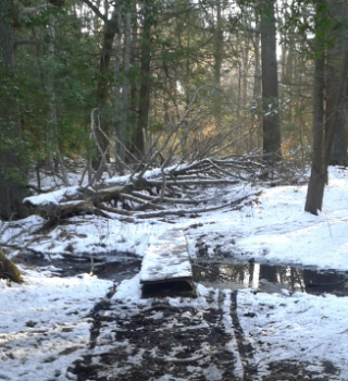
a plank bridge leads you over a wet land area.
A short way down the trail, you will come upon a shorter version of the plank bridge.
Soon the Longwater Brook can be seen through the forest, and the sound of running water will catch your attention.

The trail will turn right at .74 and cross a bridge over the fast running water (in early spring).
The trail leads straight with a neighboring house in your line of vision. Another access trail leads left with the trail curving slightly to the left.
At .86 there will be another long bridge and afterward a gentle uphill climb.
The hiking trail continues its winding nature and soon climbs more moderately.
It crests the hill at .93.
Another access trail leads to the left while our journey to the left is open looking.
Just after the Cedar Elementary and the High School can be seen.
At 1.05 the access trail from the parking area near these two leads to the left. The trail continues straight and passes what appears to be a vernal pool.
Just after the trail turns right and leads behind fenced in fields behind the High School.
Not particularly fond of this part of the hiking trail, but as a cross country ski trail it makes sense.

At 1.35 the beaten grass trail leads onto a gravel road. This is a fairly wide level surface.
It comes to an intersection where straight is an access road behind more school fields and the hiking trail continues as a gravel road taking a right back into the forest.
Soon small white squares appear as markers and the orange ties make an appearance as well.

At 1.58 the hiking trail crosses a culvert and then leads out turning right onto the far end of the field at the middle school.
The trail once again leads across the edge of the field to another end where some soccer nets and a retaining fence are placed.
The trail enters the forest once again behind the chain link fence that helps to keep balls from getting lost in the woods.
Soon to the left, a white square marker can be found on a tree. Attached to it is a code for a trail map.
The orange markers continue here as well. Soon the trail is traveling on a high area once again above wetland below.
At 1.83 the hiking trail leads back to the original intersection where the loop begin.
Returning out to the parking spot along the entrance makes the trip a full 2.20 miles.
The Colby Phillips Trail is across the street if you feel the need to continue on!
- South Shore Hiking Trails ›
- Hanover ›
- Melzar Hatch Reservation
Recent Articles
-
Eaton Pond Conservation
May 11, 23 12:38 PM
 The Eaton Pond Conservation sitting on the Braintree/ Quincy line is a wonderful hiking area with a varied mix of history and assorted landscape.
 -
Bradford Torrey Sanctuary update
May 09, 23 10:34 PM
Visit the completely updated version of the trail and sanctuary description and it's highlights. The town of Weymouth did a spectacular job of cleaning this gem up with several trailheads established… -
Ellis Estate Trails
Jun 08, 21 11:07 PM
 The Ellis Estate Trails in North Scituate are a collections of trails winding in and around the property they are named after.

Trail
Quick Facts
Directions:
From exit 35 head north on Rt 228 (if coming from the north, if coming from the south, head south) .
At the next set of lights turn onto Pond St. Follow Pond St into Hanover where it becomes Whiting St. At intersection with Rt 123 continue straight. Approx. one mile on the left, just after Old School House Lane will be the Hanover Middle School. Park along the entrance to the school or non designated spaces in the lot.
Parking:
Plenty of parking for several vehicles
Trail length:
Light to moderate
Difficulty:
Easy
Water:
Drinkwater River and Longwater Brook
Other activities:
cross country skiing, snow shoeing, bird watching

New! Comments
Have your say about what you just read! Leave me a comment in the box below.