hiking trails of hanson
indian crossway of bay circuit trail

One of the hiking trails of Hanson goes through the Burrage Wildlife Management Area. There are several trails throughout the management area, this particular one follows a historic route once regularly used by Native Americans in and before colonial times.
This route is referred to by historians as the Indian Crossway. It is an area of higher ground the Indians used to navigate through the cedar swamp on this now state owned conservation land.
To follow this route, start at the gate and parking area for the Burrage Wildlife Management Area located on Elm St., follow the paved road down past a working cranberry bog on the left.

Once down to this area,
the trail transitions to a sandy dirt road.
At approximately 1/4 mile
the trail takes a left on to a
small utility line with a trail
running along side it.
The trail markers for this trail are a bit confusing.
Just past the cranberry bog,
you will notice a marker that
makes it seem that the Bay Circuit
Trail follows the sandy road straight ahead.
Following this left along the hiking trail only a short distance, the familiar dollar sized white rectangles that mark the Bay Circuit Trail will appear on the left.

tree on the left
of this trail
has a marker
Just past the first sighting
of these, the trail makes a
short jog to the left and
enters the forest running parallel to the power line.
The Indian Crossway hiking trail runs about another 1/4 mile on a cart path through pleasant forest ending this portion of the excursion to a bit of an opening at the utility line.
It then continues on a narrower path across the northern portion of the Great Cedar Swamp.

Here the trail emerges
from the forest to the
start of the crossway

This portion is the most
likely original route of
the Native American.
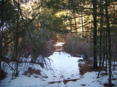
The trail becomes a bit more difficult to traverse as the area is water filled in almost any season. In the warmer months I had been through here and found tires placed in the hardest to cross areas.
This time I am here in winter and those places are frozen over but can be dangerous as ice lay beneath a thin layer of snow. Very slippery!!

Though this part of the
hiking trail is challenging,
it is also the highlight
of the trail and the
most rewarding!

Not only will you find
wonderful views of the
Great Cedar Swamp,
a large part of the bird
population can be found
along this hiking trail
as well!
One of the rewards for attempting this crossing is the heavy bird population that dwell among the heavy thicket lining the crossway.
This thicket thins out with views on both sides of this crossway hiking trail.

At the other end of the swamp crossing at just over 1 mile, the trail passes through an old gate that at one time was put there most likely by the Northern Cranberry Company.
The trail divides into three and widens out here.
The blazes that mark the Bay Circuit Trail have vanished at this point.
One trail goes straight, continues as a cart path and is most likely the route of the BCT, this continues as another pleasant forest trail.
Another turns to the right, leads out and follows the utility line.
The third takes a deep left, this one continuing wide enough to be a road.
This third trail to the left runs along the top boundary of the swamp.
It is probably the one most taken, as the views of the cedar swamp continue.
If continued on to its full, this trail will run down into private property.
Information about this area says that formerly it was used as a dump and
the trail heading to the left backs this up. The road will take a deep
right and at this point many tires and debris of all sorts will be found
here.
After this debris but before entering the private property there will be two additional trails to the right.
All three trails and the two additional ones before the private property will join at the same junction.
The trail junction that continues on through the area may not be readily visible as many trees have fallen and block a good portion of the trail.
Getting past the blocking trees, the trail becomes visible once more.
This portion of the trail passes over an area that one traveling on the utility line portion of the split trail cannot pass over.
The utility lines run over an area that goes downhill and over water.
This junction part of the trail runs to the side of this, opening up to more views of the Upper Burrage Pond and the swampy part of that pond.
Getting past this part of the upper swamp the trail will take a left on another trail that again is blocked by fallen trees.

A small cut through
path has been worn
through to get around the
fallen trees.

The hiking trail goes through a short bit of forest and then opens up to a bit of an open area, not quite a field but open.
Here you will find a Kiosk, void of information sadly, and then a gate leading out to crocker place.

The Bay Circuit Trail takes a right and continues down Crocker Place out to Route 27 or Main St. Depending on which route taken at the trail junction split after the crossway, this hike will take anywhere from 1 1/2 -2 1/4 miles.
- South Shore Hiking Trails ›
- Hanson ›
- Indian Crossway
Recent Articles
-
Eaton Pond Conservation
May 11, 23 12:38 PM
 The Eaton Pond Conservation sitting on the Braintree/ Quincy line is a wonderful hiking area with a varied mix of history and assorted landscape.
 -
Bradford Torrey Sanctuary update
May 09, 23 10:34 PM
Visit the completely updated version of the trail and sanctuary description and it's highlights. The town of Weymouth did a spectacular job of cleaning this gem up with several trailheads established… -
Ellis Estate Trails
Jun 08, 21 11:07 PM
 The Ellis Estate Trails in North Scituate are a collections of trails winding in and around the property they are named after.
Trail
Quick Facts
Directions:
From route 3 take exit 38 toward Abington. Follow route 18 through South Weymouth, Abington and then into Whitman. Take a left at Route 27. Follow this through Whitman and continue following route 27 as it takes a right on Franklin St.
Follow Route 27 into Hanson. Take right at Elm st. about a mile from the
intersection with route 14. Entrance approx. 1 1/2 miles on left to Burrage Wildlife Management Area.
Other end of trail is further south on Route 27 near end of Crocker Place. Trail is on left just after railroad tracks.
Parking:
Elm st. end can hold 4-6 vehicles with parking across the street.
Crocker Place may be an inconvenient parking spot.
Trail Time:
Moderate: 1 1/2- 2 1/2 miles depending on route taken.
Difficulty:
Easy to Moderate:
Some seasons may make travel more difficult.
Water sources:
Upper Burrage Pond
Other activities:
Bird Watching, x-country skiing, snow shoeing

The Indian Crossway is located on the northern portion of the Burrage Wildlife Management trail map.
New! Comments
Have your say about what you just read! Leave me a comment in the box below.