hiking trails of duxbury
duxbury bogs


The hiking trails at Duxbury bogs are a nice
mix of wide open sandy roads around both
working and abandoned cranberry bogs.
There are narrow paths that lead through the
abandoned bogs. These have become meadow
like and create a safe haven for a variety
of bird life.
The main entrance and parking lot are on East St.
While this location makes it a bit tucked away in a quiet area of Duxbury, it is easily seen from route 3.
The main trails crisscross around and through the bogs, while the Bay Circuit Trail runs through and then to the side of an Esker that divides the bogs with another smaller pond.

On the eastern side of the bogs is a pond called Golden Reservoir, simply called Sunken Forest on many maps.
The many tree stumps from an ancient forest emerge eerily from the pond creating another highlight of hiking trails through the area.
While there are many different possibilities for hiking this area, I will describe a 2 mile route that touches most of the features of this property.
A two mile hiking trail route around and through duxbury bogs

Parking in the lot on East St, I headed on the sandy dirt road leading straight down into the bogs.
The hiking trail loops here in front of the parking area and one can easily go to the right, but I always seem to take to the left.
Like many other properties I have visited, my first impression of the Duxbury Bogs was that it is a loop trail around a single bog.
Once on the property, it soon becomes obvious that it is much larger.

As soon as a tenth of a mile, one of the trail loops enters from the right.
The trail becomes a bit rocky and rough after this first intersection.
Then at 1/3 mile another intersection with another loop around a bog to the left noted as Old Bog on the map. The hiking trail taking a hard left.
A more soft left leads you on the Bay Circuit Trail portion in the bogs.
I take the hard left which becomes a grassy roadway with a narrow dirt track in the middle.
Soon it leads to all grass as it winds its way around this side bog.

Along the way, on the hiking trail around the Old Bog,
there are many narrow wooded paths leading off to the left.
Thinking these were just paths leading to private property,
I did not explore any.
Looking at the map, some of these may climb to the top
of any of the eskers on the property.
 View at the side of the pump house at the Old Bog of Cranberry Factory Pond.
Continuing on, as the trail curves to the right I disturb a blue heron, of which there are several types of heron residing here in the Bogs.
The trail soon comes to a small pump house and goes to the right, but I go left to explore part of the BCT.
At 3/4 miles the trail starts as a road and turns grassy and narrow.
 The hiking trail route now follows a portion of the Bay Circuit Trail through Duxbury Bogs.
The hiking trail now turns left on a continued
narrow track and enters the forest.
To the right the land runs uphill.
It is here that the trail lines the esker.
The trail will soon widen to a cart path
and run along Cranberry Factory Pond to the left.
 The trail narrows and leads beside Cranberry Factory Pond below an Esker.
At about one mile a side path will lead out to the pond.
There are a couple of trails up the esker that I did not explore.
One steep and straight up, another climbed in a more gentle switch back motion.
Soon after the trail narrows again and crosses the stream that feeds the pond by a boardwalk.
There is a trail that leads to the right and the BCT goes left here.
 The very narrow hiking trail!
The trail leads across the lower end of the pond
and becomes very narrow, widens again, leads through
a wet area that has an alternate board walk for wet weather.
The trail narrows once again becomes grassy and leads out to Mayflower Rd.
 Along the way here, are the best views of Cranberry Factory Pond!
The BCT continues left down Mayflower Rd. I turn right, for a circuit trail back into the bogs.
At approximately 1.15 I return to the bog road. Along the way another older bog is to the left on Mayflower Rd.

Following the first bog road I come to, follow straight til a narrow path that leads to the left.
If time or effort is short, leading straight I bring you directly back to the parking area.
Leading left will bring you through the meadow like part of the bogs.
 Looking to the left you will view mayflower bog
Grassy, overgrown and filled with wildlife, it is my favorite part of the hike.
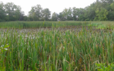
To the right is an area that looks like a wetland when I visit. On the map it refers to a pond here. My visits here are during the drought time of summer 2016.

The trail will lead over a little bridge and
on the other side of this older bog.
On the other side at 1.40 take a right leading into a bit of forest that will soon run along Golden Reservior which contains the sunken forest.
Many sunken forests in the New England area are found off the ocean shores.
Here on the south shore it was estimated that the shoreline extended 75 miles further into the ocean than where our current shoreline exists.
All sunken forests are formed when a glacier in the area, thousands of years ago melted and caused water levels to go up.
Many areas of forested lands became submerged and the mud that encapsulated the forest also preserved it.
Many times the stumps left in the sunken forests are thousands of years old. The formation of Eskers in the Duxbury Bogs help prove of evidence of glacial activity here.
If you do not know what an Esker is my page of Great Esker Park in Weymouth will explain.

The trail is once again wide and road like and leads alongside the Sunken Forest.
 Many views of this phenomenon emerge here.
At 1.5 miles the hiking trail will leave
the sunken forest area and enter a
bit of wooded land climbing uphill.
It continues on a wide road like trail
above the sunken forest with limited views
and then descends and meets alongside
one of the bogs once again.

Now the hiking trail is a wide open gravel route with scenic openings to the sunken forest and views of route 3 beyond.
At 1.85 there is a bog cross path to the right.

The parking area will come into view
and the trail takes a curve to the right.
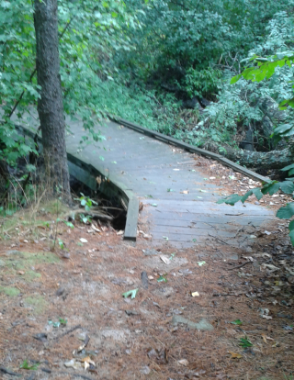
Soon after the trail crosses another bridge
just before the two mile mark.
The last bit of trail to the parking area makes it to the two mile mark.
- South Shore Hiking Trails ›
- Duxbury ›
- Duxbury Bogs
Recent Articles
-
Eaton Pond Conservation
May 11, 23 12:38 PM
 The Eaton Pond Conservation sitting on the Braintree/ Quincy line is a wonderful hiking area with a varied mix of history and assorted landscape.
 -
Bradford Torrey Sanctuary update
May 09, 23 10:34 PM
Visit the completely updated version of the trail and sanctuary description and it's highlights. The town of Weymouth did a spectacular job of cleaning this gem up with several trailheads established… -
Ellis Estate Trails
Jun 08, 21 11:07 PM
 The Ellis Estate Trails in North Scituate are a collections of trails winding in and around the property they are named after.
Trail
Quick Facts
Directions:
From the North
From exit 20 on route 3 head west (right) on Tremont St Rt 3A toward Kingston. At the lights turn right on route 53. Follow to a small rotary and take the first right on Winter St.Take a left on Summer St and the first right on East St.The parking area will be on the left before the route 3 overpass.
From Exit 22, take a left on Congress St (route 14). Take the next left on Chandler St. Approx.1/2 mile on left is Mayflower St. The other end of the bogs are here.
Parking:
7-10 vehicles at East St parking.
4 vehicles at the Mayflower St end.
Trail Time:
Moderate: 2 mile guide described but loads of other possible routes.
Difficulty:
Easy: Mostly flat only hill on main trails is after sunken forest. Other more strenuous side trails exist leading up the eskers, but are optional.
Water sources:
sunken forest, cranberry factory pond and the streams that feed and run through the area
Other activities:
Bicycling, cross country skiing, snow shoeing

Dogs:

New! Comments
Have your say about what you just read! Leave me a comment in the box below.